Commercial
Nocturnal Paris Diorama Map
Likes
3
Views
43
 Orelon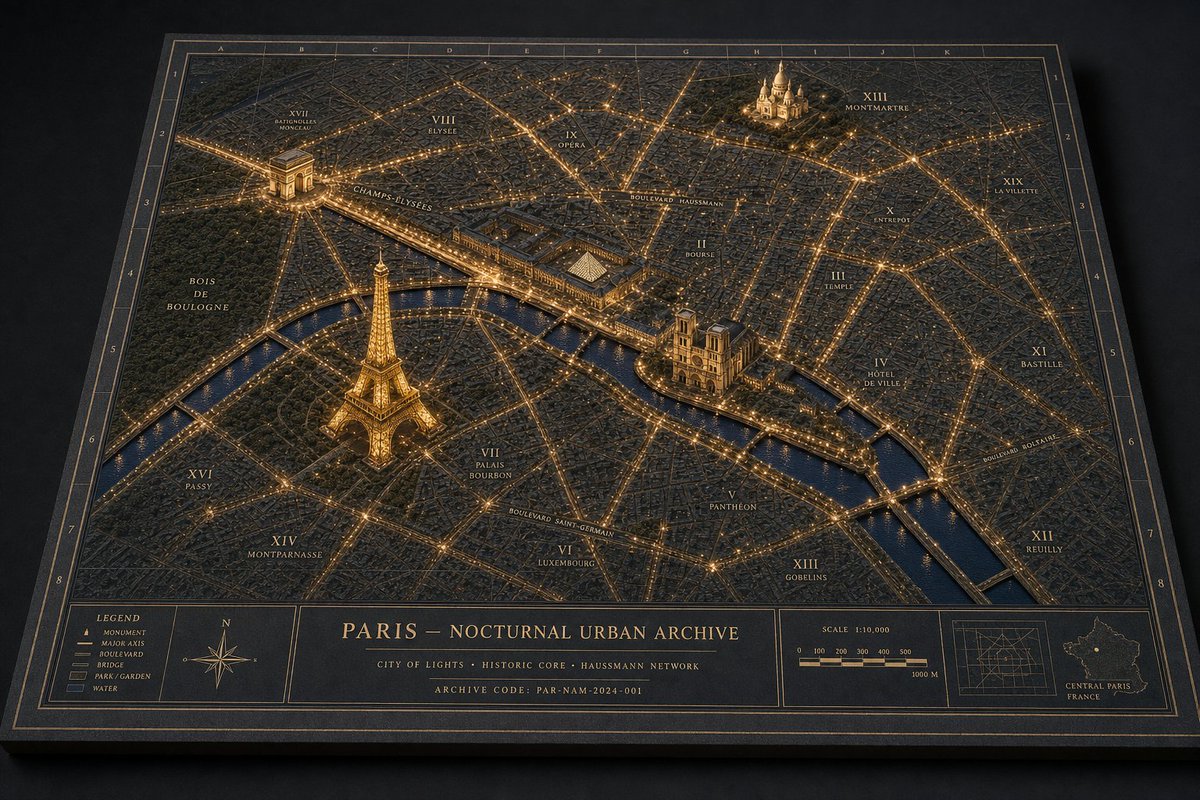
Commercial
Goal: Create a premium 3D architectural diorama map of {argument name="city name" default="Paris"} at night, presented as a physical archival board titled {argument name="map title" default="PARIS — NOCTURNAL URBAN ARCHIVE"}. Canvas: Landscape 3:2 view, photographed from an oblique overhead angle on a dark tabletop. The map is a thick rectangular black board with beveled edges, thin gold border lines, coordinate grid labels along the top and sides, and a refined museum-archive aesthetic. Visual style: Dark navy and charcoal physical map texture, raised miniature city blocks, engraved streets, warm golden illumination tracing major boulevards and intersections, glossy deep-blue water, subtle cinematic shadows, high-detail miniature model craftsmanship, luxury cartography, brass-and-ink color palette. Main map content: Show a nighttime miniature urban plan with illuminated road networks and raised landmark models. Include exactly 4 prominent 3D landmarks: 1) Eiffel Tower glowing gold in the lower-left/central-left area near the river, 2) Arc de Triomphe in the upper-left area with radiating avenues, 3) Notre-Dame-like cathedral on an island or riverbank near center-right, 4) Sacré-Cœur-like basilica on a hill in the upper-right area. Include one winding river crossing the map diagonally from left to lower-right, with multiple bridges, dark reflective water, and golden riverside lights. Map labels: Use elegant small-cap serif labels in gold ink. Include exactly 20 arrondissement-style district labels: I Louvre, II Bourse, III Temple, IV Hôtel de Ville, V Panthéon, VI Luxembourg, VII Palais Bourbon, VIII Élysée, IX Opéra, X Entrepôt, XI Bastille, XII Reuilly, XIII Gobelins, XIV Montparnasse, XV Vaugirard, XVI Passy, XVII Batignolles-Monceau, XVIII Butte-Montmartre, XIX La Villette, XX Ménilmontant. Also label major routes and areas including Champs-Élysées, Boulevard Haussmann, Boulevard Saint-Germain, Boulevard Voltaire, Bois de Boulogne, and the River Seine. Bottom information band: Add a wide cartographic footer divided into exactly 5 panels: 1) left legend box, 2) compass rose box, 3) large centered title block, 4) scale bar box, 5) right inset-map box. The legend box must list exactly 5 items: Monument, Major Axis, Boulevard, Bridge, Park / Garden, Water. The centered title block contains the map title, a subtitle reading "CITY OF LIGHTS · HISTORIC CORE · HAUSSMANN NETWORK", and an archive code reading "ARCHIVE CODE: PAR-NAM-2024-001". The scale panel shows "SCALE 1:10,000" and a 0 to 1000 m scale bar. The right inset panel shows a small grid map and a tiny outline map labeled "CENTRAL PARIS FRANCE". Constraints: Keep all typography crisp and plausible, no people, no vehicles, no modern UI, no photoreal skyline beyond the raised map surface. The entire image should feel like directing a miniature nocturnal urban world: layered landmarks, physical map materials, coherent architectural-diorama language, and warm night lighting.
This is a free AI prompt from the Orelon library. Thousands more image prompts here are free to copy and adapt.
Explore more image prompts


Ready to create
Start with this curated direction in Orelon, then shape it into your next visual.