
Commercial
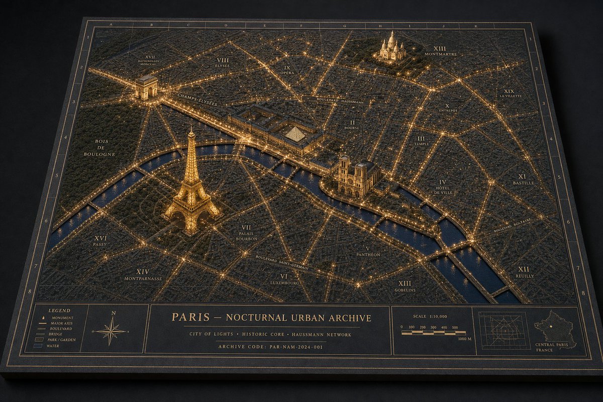
Nocturnal Paris Diorama Map
点赞
3
浏览
43
Commercial
Goal: Create a premium 3D architectural diorama map of {argument name="city name" default="Paris"} at night, presented as a physical archival board titled {argument name="map title" default="PARIS — NOCTURNAL URBAN ARCHIVE"}. Canvas: Landscape 3:2 view, photographed from an oblique overhead angle on a dark tabletop. The map is a thick rectangular black board with beveled edges, thin gold border lines, coordinate grid labels along the top and sides, and a refined museum-archive aesthetic. Visual style: Dark navy and charcoal physical map texture, raised miniature city blocks, engraved streets, warm golden illumination tracing major boulevards and intersections, glossy deep-blue water, subtle cinematic shadows, high-detail miniature model craftsmanship, luxury cartography, brass-and-ink color palette. Main map content: Show a nighttime miniature urban plan with illuminated road networks and raised landmark models. Include exactly 4 prominent 3D landmarks: 1) Eiffel Tower glowing gold in the lower-left/central-left area near the river, 2) Arc de Triomphe in the upper-left area with radiating avenues, 3) Notre-Dame-like cathedral on an island or riverbank near center-right, 4) Sacré-Cœur-like basilica on a hill in the upper-right area. Include one winding river crossing the map diagonally from left to lower-right, with multiple bridges, dark reflective water, and golden riverside lights. Map labels: Use elegant small-cap serif labels in gold ink. Include exactly 20 arrondissement-style district labels: I Louvre, II Bourse, III Temple, IV Hôtel de Ville, V Panthéon, VI Luxembourg, VII Palais Bourbon, VIII Élysée, IX Opéra, X Entrepôt, XI Bastille, XII Reuilly, XIII Gobelins, XIV Montparnasse, XV Vaugirard, XVI Passy, XVII Batignolles-Monceau, XVIII Butte-Montmartre, XIX La Villette, XX Ménilmontant. Also label major routes and areas including Champs-Élysées, Boulevard Haussmann, Boulevard Saint-Germain, Boulevard Voltaire, Bois de Boulogne, and the River Seine. Bottom information band: Add a wide cartographic footer divided into exactly 5 panels: 1) left legend box, 2) compass rose box, 3) large centered title block, 4) scale bar box, 5) right inset-map box. The legend box must list exactly 5 items: Monument, Major Axis, Boulevard, Bridge, Park / Garden, Water. The centered title block contains the map title, a subtitle reading "CITY OF LIGHTS · HISTORIC CORE · HAUSSMANN NETWORK", and an archive code reading "ARCHIVE CODE: PAR-NAM-2024-001". The scale panel shows "SCALE 1:10,000" and a 0 to 1000 m scale bar. The right inset panel shows a small grid map and a tiny outline map labeled "CENTRAL PARIS FRANCE". Constraints: Keep all typography crisp and plausible, no people, no vehicles, no modern UI, no photoreal skyline beyond the raised map surface. The entire image should feel like directing a miniature nocturnal urban world: layered landmarks, physical map materials, coherent architectural-diorama language, and warm night lighting.
这是 Orelon 提示词库里的一条免费 AI 提示词。这里还有成千上万条图像提示词,都能免费复制和改用。
探索更多图像提示词


准备好就开始
从这条精选创作方向开始,在 Orelon 中塑造你的下一张视觉作品。